January 2023 will go down in the record books as one of the stormiest, snowiest, and rainiest months for many parts of California. As of January 16th, San Geronimo Valley had received 19 inches of rain--making it our second-wettest January in the last decade (after 2017). In addition, the wind, landslide, and flood damage has been widespread. And the month is only half over. Much of that was packed into the first 11 days.
The story starts in December, after a dry October-November start to the 2023 water year (following 3 dry years). Here in San Geronimo Valley, I measured 16.59 inches of rain in December, at 240% of average, the wettest December in 8 years and second-wettest in the last decade.
Logs began moving in San Geronimo Creek in early December, when a series of storms brought rare lightning and thunder, and enough rain to get San Geronimo Creek up to 200 cfs. This was not a large flow, but trees fell in the creek and rafted down to an engineered logjam that was placed in the creek in 2020. An October 2021 storm that peaked at 2,500 cfs had already moved around the logs connected to boulders in this logjam--logs that were designed to stay in place. Surprisingly, a log that didn't move in 2021 was scooted several feet downstream by the 660 cfs flow on December 27th, 2022. It stopped when the boulder it was anchored to bumped up against another log embedded in the creekbed.
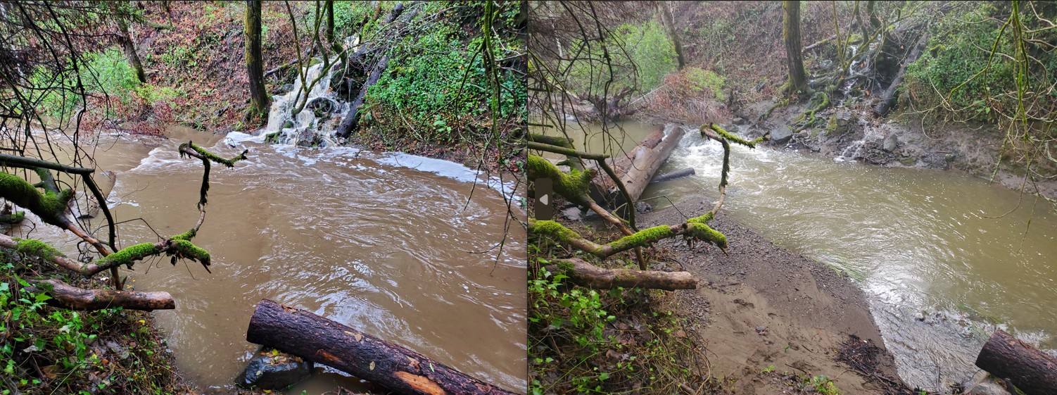 |
| Note the moving log bolted to a boulder at the lower right corner of the photos on December 10th (left) and December 28th (right). |
Two storms at the end of December were impressive. The one on the 27th dropped half-an-inch of rain an hour for six hours. Once again there was rare lightning and thunder. Read about "snow level bending" as freezing levels fluctuated near Lake Tahoe. Twenty-two foot waves towered along the coast.
 |
| On December 26th, 2022, seventeen-foot waves were oversteepened and trailing banners of spray because of the east wind. They foreshadowed the 22-foot waves that were forecasted on the 27th. |
Then the New Year's Eve storm dropped almost four inches of rain in a day-and-a-half. San Francisco got 5.45", closing Hwy 101 and making it the second-wettest day since 1849. This is the storm that broke a levee along the Cosumnes River, and dropped heavy rain (11 inches in parts of the Central Sierra) and then heavy snow in the Lake Tahoe area, setting a new record snowfall rate of 7 inches of snow in one hour and nearly a record 46 inches of snow in 12 hours.
Here at home, the New Year dawned clear and sunny, with the first significant rain of the new year falling on the afternoon of Monday the 2nd. A few trees in San Geronimo Valley had already toppled, and a log that had been placed in San Geronimo Creek during a habitat enhancement project had ripped out of a boulder that it had been bolted to and floated downstream, rafting up against another engineered logjam. It was strapped in just before the well-advertised storm on Wednesday the 4th, then lopped and chained in after the storm (and the dangerous protruding bolt was cut off).
 |
| Before (left - Dec 28), new log strapped in with bolt sticking out (middle - Jan 4), and lopped and chained in (right - Jan 6). The log really bounces around during high flows. |
The first of several strong January atmospheric rivers slammed into California on the 4th day of the new year. After 4pm the front came through with crazy south winds and heavy rain, causing the electric power to flicker. It was more windy, not so rainy, and lots of trees in San Geronimo Valley fell. Almost every road and trail was blocked by downed trees during this storm. Winds of over 100 mph were recorded near Nicasio Reservoir.
Just upwind of Nicasio Reservoir, the north ridge of San Geronimo Valley peaks at about 1,400 feet elevation. There is a saddle east of the highpoint that funneled the south winds, where three large trees snapped--two of them redwoods--and at least half a dozen other trees were uprooted and fell. All fell pointing to the north. It must have been incredible and scary when the wind peaked at this ridgetop location. What wind speeds does it take to snap redwoods three feet in diameter (at the edge of a ridgetop clearing)?
Many trees also fell on the San Geronimo Valley Commons. The large pond near Roy's Redwoods overtopped its banks, with strong winds funneling through the gap where the footbridge crosses Nicasio Valley Drive hitting the pond and rafting thatch to the high water mark. An inlet culvert was pressurized and leaked, eroding a hole near the pond.
 |
| Two large redwoods snapped, and fell pointing north, presumably during the strong south winds on January 4, 2023. At least half a dozen other ridgetop trees at this location were uprooted and fell pointing north. |
 |
| Thatch rafted up over the banks of the pond, marking the high water level on the downwind-side of the pond. |
 |
| The ridgtop gap where at least ten trees snapped or fell is a little clearer now. |
 |
| Red arrow points to the ridgetop gap where ten downed trees point north; yellow circle on the left is a downed tree pointing northwest; yellow circle on the right is the northwest side of the pond where rafted thatch marks the high water line; green arrow is Nicasio Rd (for reference). |
 |
| 2023 Water Year precipitation as of January 16, 2023. 34.58" is 84% of our annual average. |

No comments:
Post a Comment