Tuesday, December 11, 2018

Shadows of Rain

We have all heard of "rain shadows," where precipitation declines "precipitously" in the lee of a mountain range. California has many examples--you'll see the phenomenon eastward of any major mountain range.

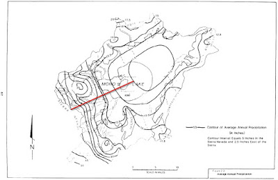
The Mono Basin has a classic rain shadow--over forty inches of annual precipitation at Tioga Pass, on the crest of the Sierra, and about seven inches on the east side of Mono Lake. Those two locations are separated by an elevation difference of 3,500 vertical feet and a distance of 15 miles.

Isohyetal map of the Mono Basin from Vorster, 1985. Red line depicts the
precipitation gradient discussed in this blog.

Saturday, November 3, 2018

Cannibal Water, Part 3

So how do we wean water users off cheap, addictive Cannibal Water?

Cannibal Fork, brought back from the South Pacific by a friend, Mike Klapp.
For urban users, it is not a problem. Urban water use has been declining for decades. Continue investing in efficiency, water recycling, stormwater capture, and groundwater recharge. Don't invest in expensive, carbon-intensive, fish-killing, polluting desalination unless you are a small isolated coastal community with no other options. Brackish groundwater desalination is okay. Avoid growth, which makes every problem worse, and eats up any water savings you achieve. But if you do plan to grow forever, then you need to make sure your long-term water strategy continues to cut water use to the point where kids will grow up not knowing what a water fight is. Not just squirt guns, I mean a really good one, with hoses and buckets. And growing forever would also require suspending some physical laws of nature, so we might as well stop growth now, while some parts of California are still nice places to live.

Sunday, October 14, 2018

Cannibal Water, Part 2

So what is "Cannibal Water"? Cannibal Water is water that when diverted, pumped, used, or disposed of after use, destroys the system itself.

Gartrell et al. describe "System Water" as the portion of water going to the ecosystem that is "required to protect the quality of diversions by farms and cities that rely on exports from the Delta or use water locally." (PPIC 2017) What would happen if people started diverting System Water? Salinity would intrude into the Delta, and diversions for agriculture, municipal, and industrial purposes would have to be shut down. The underground parallel is overpumping of an aquifer, allowing salinity intrusion, which then prevents the use of that aquifer.

The water diverted that would result in these negative effects is Cannibal Water, since it consists of water diverters destroying themselves by using water that destroys the system upon which they depend.

Friday, September 14, 2018

Cannibal Water, Part 1

Everyone loves freedom. People should be able to do whatever they want, unless it negatively impacts someone else. Being a good neighbor, kind, and respectful towards others, comes first. If you behave that way, then fine, do whatever you want. I am a libertarian at heart. Everyone should get what they want, and everyone should want what is best for everyone else. Yeah, that would be a perfect world, huh?

Property rights activists are on the other end of the spectrum--they want their own interests to come first, before everyone else. They often sound like a deadbeat dad/mom, shirking their responsibilities, doing only what they want, ignoring their impacts on others.

"The necessity of pursuing happiness is the foundation of liberty. ...The pursuit of happiness, therefore, is not merely a matter of achieving individual pleasure. That is why Alexander Hamilton and other founders referred to 'social happiness.'" (Hamilton, 2008)

Monday, June 4, 2018

Navigable in Fact

I love this Outside article (Drawing a line in the sand over river rights, by Chris Colin)--I love that someone did this. Raising awareness of when public rights are being usurped by private interests is always a good thing. And this one is close to my heart--for a while I made it a hobby to float any and all navigable waters (the smaller the better). And when you spend a lot of time outside off the beaten track, you run into private property obstacles and questions all the time.

Sometimes you have to combine skiing and
kayaking to get where you want to go. Stumps
in the distance are below the high water line of
Grant Lake Reservoir.
Easement Etiquette
As much as I like the article, I don't approve of how the author went about exercising his rights. It made for a good article, but there needs to be some etiquette when exercising the right to use prescriptive easements and navigability easements and sovereign lands:
     1. Be courteous - respect wildlife, other recreationists, the privacy of adjacent property owners, and avoid dwellings
     2. Leave no trace
     3. Be invisible, if possible - if they don't know you are there you won't get hassled
     4. Contact property owners and agencies when the public is being bullied, and bring wire cutters (e.g. look up the East Walker River from the Hwy 395 bridge--if you wanted to float it, you would need them).

Essentially, behave like you are in a campground. Respect the campers in the campsites you are next to (or you are taking a shortcut through if no one is home).

Special Cases
The problem is that the Russian River situation is rare. Where the public's rights are clear, and the property owners are clearly violating them, that is a good place to write an article to raise awareness. But those situations (in California) are the exception. Here grey areas are the rule. The following are categories of grey areas I've encountered.
Thursday, May 3, 2018

Avalanches, Ticks, and Delta Smelt Salvage

I joke that when I go for a run on the trails around my home in San Geronimo Valley, I'm doing tick surveys. Which is essentially true--one method of catching ticks for study is to drag fabric through grass, and the ticks latch on. That is what I do when my legs brush past grass and twigs.

I don't keep formal track of the ticks I find--or more accurately, the ticks that find me. Which is unfortunate, because there is a nice dataset there. But from my memory, what has struck me is the variability. Just when I think I see a pattern, and understand what is going on, and formulate a hypothesis, I observe ticks in places that confound that pattern. Or I hear about others' observations that don't match my mental model.

Take this year for example. I had not seen a tick until last week, yet word on the street (or fire road?) was it was a bad tick season. So I began putting together a hypothesis about the cold December, dry winter, and very wet March: that prior to March, ticks were scarce (at least, scarce in my surveys) in grassy areas where I was running because of the low growth and short grass. Since March the heavy rain impacted the ticks in these areas in some way, possibly washing them out of the grass and drowning them.

Thursday, April 5, 2018

Last Ride on the Red Car - April 8, 1961

My dad grew up in L.A. during interesting times. His parents worked for the Pacific Electric--the operator of the extensive network of electric train lines in Southern California during the early 20th century. He rode on them as a kid, and grew to love trains and electricity, making the former a hobby and the latter a career.


57 years ago--April 8, 1961--my dad had his last ride on the red car. The buses, the sprawl, and the automobile took over, and the last electric passenger train ran in L.A. (until L.A. to Long Beach line was rebuilt in the 1980s).

The L.A. Long Beach
Interurban Train:
On Saturday evening April 8, 1961
Easter Saturday with Joseph Sweeney I had my
last ride on the red car, round trip Watts to
Slauson. In both cases two cars were coupled.
One conductor was glad to see them go, the other
was on the point of crying. When we got off at
Watts there was a long farewell blowing of the
whistle for 103rd St. crossing & a pedestrian and
the northbound train came very shortly with it's
farewell.

Saturday, March 17, 2018

3. Central Coast Canyon

#WithoutTheRoar Quiz: Where in California am I?

You walk up a dirt road, entering the bottom of a canyon next to a sycamore-lined creek. You see a classic mix of Central California vegetation: yucca, northern monkeyflower, coastal sagebrush, deerweed, coyotebush, poison oak, bay, coast live oak. There are a few non-natives, notably eucalyptus trees on the hillside to the south. The former sheep pastures at the entrance of the canyon are now covered in relatively new housing and parking lots. Once you are through the narrows, the canyon opens up into grassy hills beyond a ranch house. Horses graze among unique dilapidated structures.


Where is this? Guess at #WithoutTheRoar.

Click here for Quiz 2.

Sunday, February 4, 2018

I lost my ice axe on Mt. Borah, Idaho

Well, I didn't exactly lose my ice axe. I stashed it under a bush at timberline on my way up, after hearing a report of the snow field crossing from another hiker--I knew I wouldn't need it--and when I came back down, it was gone.


Last August I climbed the highest peak in Idaho. It was the day before the total solar eclipse, and the mountain was in the path of totality. It would be a zoo on any summer weekend, but it was extra busy that weekend--the rangers I spoke to were expecting three times the normal crowds. 150 people instead of the usual 50.

Tuesday, January 30, 2018

First Frostless January

Since we moved to San Geronimo in 2011, January has warmed tremendously. Frosty days at or below 32 F have disappeared completely:

  • 2012 - 31% of days were frosty, and 25% of days were in the 20s
  • 2013 - 53% of days were frosty, and 30% of days were in the 20s
  • 2014 - 58% of days were frosty, and 29% of days were in the 20s
  • 2015 - 13% of days were frosty, and 10% of days were in the 20s
  • 2016 - 7% of days were frosty, and both days were in the 20s
  • 2017 - 16% of days were frosty, and for the first time no days were in the 20s
  • 2018 - no frosty days
The green and blue minimum temperature lines show dramatic warming over the
last few years. Jan 2013-15 had less than 4% of average rainfall.
Luckily, this January follows a December when 63% of days were frosty. This ties 2013 for the most frosty days, well ahead of any other year.

I say "luckily" because just think of the implications of not having frost. It affects everything--fruit trees, insect activity... it also affects the length of the growing season, since February hasn't gotten below freezing since 2015 and March hasn't been below freezing since 2012.

And for only the second time in 7 years, January had no high temperatures in the 40s--the highs were at least 50 F all month. The lowest max is not shown on the graph.

Luckily, here it has rained enough to make it wetter than 2012 or 2014 at this point in the season. Unfortunately, those were our two driest years since 2011, at 70% and 51% of average, respectively.

Thursday, January 25, 2018

Reimagining San Geronimo Valley (Golf Course)

The pent-up demand for open space in the middle of a community--open space that has been locked up for use only by paying customers during business hours seven days a week for almost 50 years--is huge. In the first two weeks since the San Geronimo Valley Golf Course closed, the excitement in our community was everywhere. Even though the former golf course is closed (and warnings have been issued not to use it), and is not yet public open space, locals are heading there (especially on weekends) to play--but not just golf.

January 2, 2017 - the second day of the San Geronimo Valley
Golf Course closure. Locals were enthusiastically claiming the
newly-accessible territory. This access point was already
popular in the evenings after business hours prior to the closure.
I did see a local man heading up the closed links with his clubs. But mostly people are walking, walking dogs, birdwatching, fish watching, riding bikes, flying drones, and fishing. Reports are that local kids are catching four bass in half an hour in some of the ponds.

This desire to access a large area of flat open space in the middle of a community is huge, and visible everywhere. It is the same desire people have who want to use the L.A. River, and who convert rails to trails. It is the same desire kids have who play in parking lots on weekends or in the middle of their street when there is no traffic. This land is your land! And it isn't locked up anymore!

As Marin County begins its process for planning the transition from golf course to "Open Space" with a captial OS, I have the following advice: