January 2023 will go down in the record books as one of the stormiest, snowiest, and rainiest months for many parts of California. As of January 16th, San Geronimo Valley had received 19 inches of rain--making it our second-wettest January in the last decade (after 2017). In addition, the wind, landslide, and flood damage has been widespread. And the month is only half over. Much of that was packed into the first 11 days.
The story starts in December, after a dry October-November start to the 2023 water year (following 3 dry years). Here in San Geronimo Valley, I measured 16.59 inches of rain in December, at 240% of average, the wettest December in 8 years and second-wettest in the last decade.
Logs began moving in San Geronimo Creek in early December, when a series of storms brought rare lightning and thunder, and enough rain to get San Geronimo Creek up to 200 cfs. This was not a large flow, but trees fell in the creek and rafted down to an engineered logjam that was placed in the creek in 2020. An October 2021 storm that peaked at 2,500 cfs had already moved around the logs connected to boulders in this logjam--logs that were designed to stay in place. Surprisingly, a log that didn't move in 2021 was scooted several feet downstream by the 660 cfs flow on December 27th, 2022. It stopped when the boulder it was anchored to bumped up against another log embedded in the creekbed.
 |
| Note the moving log bolted to a boulder at the lower right corner of the photos on December 10th (left) and December 28th (right). |
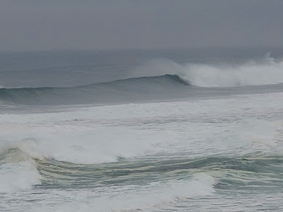
Two storms at the end of December were impressive. The one on the 27th dropped half-an-inch of rain an hour for six hours. Once again there was rare lightning and thunder. Read about "snow level bending" as freezing levels fluctuated near Lake Tahoe. Twenty-two foot waves towered along the coast.
 |
| On December 26th, 2022, seventeen-foot waves were oversteepened and trailing banners of spray because of the east wind. They foreshadowed the 22-foot waves that were forecasted on the 27th. |