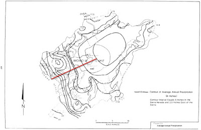
The Mono Basin has a classic rain shadow--over forty inches of annual precipitation at Tioga Pass, on the crest of the Sierra, and about seven inches on the east side of Mono Lake. Those two locations are separated by an elevation difference of 3,500 vertical feet and a distance of 15 miles.
 |
| Isohyetal map of the Mono Basin from Vorster, 1985. Red line depicts the precipitation gradient discussed in this blog. |
But the isohyetal map (a contour map showing lines of equal precipitation) on page 33 of Jules Evans' "Natural History of the Point Reyes Peninsula" had me wondering--is there really such a thing as a rain shadow, and if so, is it responsible for all that we give it credit for?
That question sounds like heresy to a hydrologist. However the remarkable thing is that the Point Reyes Lighthouse gets less than 12" per year, while Inverness Ridge gets over 40" per year. This sounds a lot like the gradient I just described in the Mono Basin, except west of a mountain range instead of east. Look at the annual precipitation west (upwind) of Inverness Ridge plotted at the same scale as the Mono Basin "rain shadow."
At a glance, those dots look pretty similar. If the same thing is happening on both west and east sides of a mountain range, why is the east side phenomenon called a rain shadow? And how is this Point Reyes "reverse rain shadow" working?
Well, you can see that the precipitation on the west side of Inverness ridge is bumped up a bit over the east side of the Sierra (the blue dots are higher than the orange dots between about zero and seven miles on the graph above). My question is: is that the rain shadow, and is the rest orographics?
Orographic precipitation is precipitation that is caused or enhanced by air flowing up and over a mountain range. It rains/snows more at higher elevations. The valleys on either side of the range are relatively dry.
Orographics is the only thing that explains the Point Reyes pattern. And while I'm not saying these two areas are directly comparable (elevations, size of the mountain ranges, longitude, and proximity to the ocean differ), I think this is a really interesting comparison.
Another indicator is that when the Eastern Sierra gets upslope precipitation, far larger volumes of precipitation than usual fall on the east slope. And often fall east of the east slope. But lake-enhanced snow may be responsible for some of that during certain conditions.
These are fun things to think about. More data would certainly pin this down, and there are certainly people who have looked into it and know.
But isn't this remarkable?

No comments:
Post a Comment