I looked at this again because my sister wanted to join the Society of California Pioneers. The application required submission of a family tree, with the membership requirement that an ancestor have been in California prior to January 1, 1850. This requirement disqualified Henry Schwerin, because although some of his brothers arrived in 1849, he didn't arrive in San Francisco until January 1850. He missed the Society's deadline by a month. So that sends us back to our dad's side of the family, and the mystery of when my great great grandparents arrived in L.A.
Sunday, November 22, 2015
To Los Angeles in the 1840s
In my last update of my genealogy research from a little over a year ago, I had discovered several new exciting leads for who and where my great great grandparents were prior to appearing in the Los Angeles 1850 census. After examining the data again, and after discovering a new baptismal record in Mexico, I am now prepared to fully go with the hypothesis I raised a year ago.
Sunday, October 4, 2015
Mono County: What it needs to do to help recover Lahontan Cutthroat Trout
When I read about California Environmental Quality Act (CEQA) lawsuits, and when I read poorly-written Environmental Impact Reports (EIRs), it makes me wish I could start a nonprofit environmental consulting firm that could set the example for doing good CEQA practice while keeping costs affordable. It really isn't that hard to follow the law and do good CEQA if you don't have an agenda other than the intent of CEQA, which includes:
One such frustrating EIR is the EIR for the Mono County General Plan Update. Now, most of this EIR is quite good. It actually impresses me as one of the better-written EIRs I've ever read. The biological resources section is a joy to read. But where it falls apart is the Cumulative Effects section.
And that is where most EIRs fail. In California, we generally don't do a good job of analyzing cumulative effects, so this EIR isn't out of the ordinary in this regard. But two wrongs don't make a right--we can and must do better. But more about that in part 2 about where Marin County fails, gets sued, and fails again.
In an EIR chock full of significant individual impacts due to policies that would encourage a build-out population of 48,702--this is a massive increase in population of a remote, rural county full of hazards and sensitive resources--the Mono County General Plan Update Draft EIR takes 4 pages of the 6-page cumulative effects section to discuss the "Water Transfer Program," a federal program to acquire water rights to protect and restore Walker Lake, Nevada and its decimated native fisheries.
- It is necessary to provide a high-quality environment that at all times is healthful and pleasing to the senses and intellect of man.
- Develop and maintain a high-quality environment now and in the future, and take all action necessary to protect, rehabilitate, and enhance the environmental quality of the state.
- Ensure that the long-term protection of the environment, consistent with the provision of a decent home and suitable living environment for every Californian, shall be the guiding criterion in public decisions.
One such frustrating EIR is the EIR for the Mono County General Plan Update. Now, most of this EIR is quite good. It actually impresses me as one of the better-written EIRs I've ever read. The biological resources section is a joy to read. But where it falls apart is the Cumulative Effects section.
And that is where most EIRs fail. In California, we generally don't do a good job of analyzing cumulative effects, so this EIR isn't out of the ordinary in this regard. But two wrongs don't make a right--we can and must do better. But more about that in part 2 about where Marin County fails, gets sued, and fails again.
In an EIR chock full of significant individual impacts due to policies that would encourage a build-out population of 48,702--this is a massive increase in population of a remote, rural county full of hazards and sensitive resources--the Mono County General Plan Update Draft EIR takes 4 pages of the 6-page cumulative effects section to discuss the "Water Transfer Program," a federal program to acquire water rights to protect and restore Walker Lake, Nevada and its decimated native fisheries.
 |
| Walker Lake, NV in the foreground, and its Mono County, CA headwaters in the background, Fall 2007. |
Friday, September 18, 2015
The Sound of Wind on Rock
After my thrilling sunrise climb of a peak in Lassen Volcanic National Park last year, I had to do it again this year. And now that the trail to the top of Lassen Peak was finally open (for the first time since 2009!), I had to climb this highest point (10,457') of Shasta County and southernmost volcano of the Cascade Range.
I left Manzanita Lake Campground in the quiet moonlit-night at 5:00 a.m, where the temperature was 39 degrees F and the wind was calm. The previous night was rainy and gusty, and the top of Lassen Peak had been skulking through puffy clouds much of the previous blustery day.
 |
| Sunrise from Lassen Peak, with Reading Peak on the right. |
 |
| Lassen Peak from Manzanita Lake the day before. |
Saturday, August 22, 2015
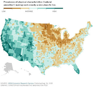
USDA blindERS misranks California counties on the Natural Amenities Scale
Last week the Washington Post posted an awesome article and maps entitled "Every county in America, ranked by scenery and climate." It includes a very cool graphic that shows each county rank as a mouseover. It also contains separate maps for each amenity used to create the overall index: average January temperature, average January days of sun, low winter-summer temperature gap, low average July humidity, topography scale, and water area as a proportion of the County. Click on the map below to go to the article.
Sunday, April 19, 2015
Why Marin County's Reservoirs are Full This Year
Is it time to remove Nicasio Dam? I've been asking myself this question ever since I came across this great report from the 1960s on the effects of Nicasio Dam on Coho Salmon and Steelhead Trout. So I added up the unused portions of Kent, Nicasio, and
Soulajule Reservoirs, since most have been kept pretty full since 1977 and all since
1992. We have a reservoir the size of Nicasio Reservoir sitting unused at the
bottom of these three reservoirs. Add unused
storage in Alpine Reservoir, and the numbers work out even better. If we allowed the full use of the reservoir
capacities of Marin Municipal Water District (MMWD), instead of always keeping them more than half full, it effectively doubles the available water storage, and would make the presence of Nicasio Dam and Reservoir unnecessary. The following graphs from CDEC show the amount of water unused sitting on the bottom of each reservoir:
 |
| Alpine Reservoir levels since 1977, adapted from CDEC. 3,500 acre-feet unused. |
 |
| Kent Reservoir levels since 1977, adapted from CDEC. 12,500 acre-feet unused. Note that the reservoir capacity was expanded in 1983. |
 |
| Nicasio Reservoir levels since 1977, adapted from CDEC. 8,000 acre-feet unused. |
 |
| Soulajule Reservoir levels since 1979, adapted from CDEC. 4,500 acre-feet unused. Note that the dam was built in 1979. |
Saturday, January 3, 2015
A Year Without Facebook
2014 was a year without Facebook. I was on it for 5 years, and in September 2013 I downloaded everything on my wall and deleted my account.
Why did I do this? It was because checking Facebook was becoming one more thing I "had" to do, like checking the mail or email. And since it sucks you in and is endless (like the rest of the Internet), it could be a colossal waste of time. And I've always found that not having something (such as a TV for most of my adult life, or a car for three years, or ice cream in the freezer) makes it a lot easier not to spend (waste) time (and money) doing it.
The final nail in the Facebook coffin was its constantly-changing privacy policies, and inflexible rules for what was public and what was private, and how much control I could have over my account. Plus the Facebook Corporation doesn't seem to be the nicest one to be supporting and giving control over my personal information.
Tuesday, October 28, 2014
No More Dam Sites
I had a day to myself, so I did what I do best: I chose to climb a peak. Naturally, it was a county highpoint--Snow Mountain East, the highest point in Colusa and Lake counties, at 7056 feet. This checks one more peak and two counties off the list. My lifelong goal is to reach the highest point in each of California's 58 counties, and I've got six more on the list that are higher than this one and nine more that are lower. At a rate of one per year lately, I've got about 15 years left on this project. The nice thing about doing this is you get to spend time in and learn about every county in the state.

Snow Mountain East is the southernmost subalpine peak in the Coast Ranges, and the closest one to the Bay Area. It isn't very close though--it takes about four hours of driving to get to the trailhead, and about an hour of that is on dirt or curvy roads. You can get there from the west through the watershed of the Rice Fork of the Eel River, whose waters are diverted to the Russian River below Pillsbury Reservoir. Or you can get there the way I did, from the east, via the Stony Creek drainage, and just to the east of that, the proposed Sites Reservoir.
Snow Mountain East is the southernmost subalpine peak in the Coast Ranges, and the closest one to the Bay Area. It isn't very close though--it takes about four hours of driving to get to the trailhead, and about an hour of that is on dirt or curvy roads. You can get there from the west through the watershed of the Rice Fork of the Eel River, whose waters are diverted to the Russian River below Pillsbury Reservoir. Or you can get there the way I did, from the east, via the Stony Creek drainage, and just to the east of that, the proposed Sites Reservoir.
 |
| View from Snow Mountain of the Sacramento Valley. The Sutter Buttes can be seen at the top right. East Park Reservoir is visible in the middle, and the much larger area proposed for Sites Reservoir is just behind the hills behind it. |
Subscribe to:
Posts (Atom)